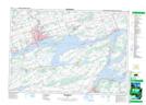
Maps showing Lake on the Mountain Provincial Park, Prince Edward, Ontario
Lake on the Mountain Provincial Park is a Conservation area located in Prince Edward, Ontario and has an elevation of 123 meters.
- Latitude: 44° 2' 26'' North (decimal: 44.0405555)
- Longitude: 77° 3' 31'' West (decimal: -77.0586111)
- Topography Feature Category: Conservation area
- Geographical Feature: Provincial Park
- Canadian Province/Territory: Ontario
- Elevation: 123 meters
- Location: Prince Edward
- Atlas of Canada Locator Map: Lake on the Mountain Provincial Park
- GPS Coordinate Locator Map: Lake on the Mountain Provincial Park Lat/Long
Lake on the Mountain Provincial Park NTS Map Sheets