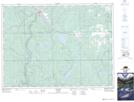
Maps showing Leeville, Timiskaming, Ontario
Leeville is a Unincorporated area located in Timiskaming, Ontario.
- Latitude: 47° 39' 30'' North (decimal: 47.6583333)
- Longitude: 80° 10' 00'' West (decimal: -80.1666666)
- Topography Feature Category: Unincorporated area
- Geographical Feature: Dispersed Rural Community
- Canadian Province/Territory: Ontario
- Location: Timiskaming
- Atlas of Canada Locator Map: Leeville
- GPS Coordinate Locator Map: Leeville Lat/Long