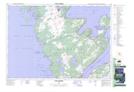
Maps showing Lion's Head Harbour, Bruce, Ontario
Lion's Head Harbour is a Bay located in Bruce, Ontario and has an elevation of 189 meters.
- Latitude: 44° 59' 21'' North (decimal: 44.9891666)
- Longitude: 81° 14' 58'' West (decimal: -81.2494444)
- Topography Feature Category: Bay
- Geographical Feature: Harbour
- Canadian Province/Territory: Ontario
- Elevation: 189 meters
- Location: Bruce
- Atlas of Canada Locator Map: Lion's Head Harbour
- GPS Coordinate Locator Map: Lion's Head Harbour Lat/Long
Lion's Head Harbour NTS Map Sheets