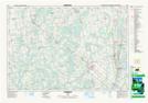
Maps showing Lueck Mill, Grey, Ontario
Lueck Mill is a Unincorporated area located in Grey, Ontario and has an elevation of 311 meters.
- Latitude: 44° 22' 47'' North (decimal: 44.3797222)
- Longitude: 80° 53' 56'' West (decimal: -80.8988888)
- Topography Feature Category: Unincorporated area
- Geographical Feature: Dispersed Rural Community
- Canadian Province/Territory: Ontario
- Elevation: 311 meters
- Location: Grey
- Atlas of Canada Locator Map: Lueck Mill
- GPS Coordinate Locator Map: Lueck Mill Lat/Long
Lueck Mill NTS Map Sheets