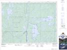
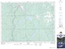
Maps showing Lundy, Timiskaming, Ontario
Lundy is a Geographical area located in Timiskaming, Ontario.
- Latitude: 47° 32' 25'' North (decimal: 47.5402777)
- Longitude: 79° 57' 0'' West (decimal: -79.9500000)
- Topography Feature Category: Geographical area
- Geographical Feature: Geographic Township
- Canadian Province/Territory: Ontario
- Location: Timiskaming
- Atlas of Canada Locator Map: Lundy
- GPS Coordinate Locator Map: Lundy Lat/Long
Lundy NTS Map Sheets
031M05 Cobalt Topographic Map at 1:50,000 scale
031M12 New Liskeard Topographic Map at 1:50,000 scale
041P08 Lady Evelyn Lake Topographic Map at 1:50,000 scale
041P09 Elk Lake Topographic Map at 1:50,000 scale
031M Ville-Marie Topographic Map at 1:250,000 scale
041P Gogama Topographic Map at 1:250,000 scale
031M12 New Liskeard Topographic Map at 1:50,000 scale
041P08 Lady Evelyn Lake Topographic Map at 1:50,000 scale
041P09 Elk Lake Topographic Map at 1:50,000 scale
031M Ville-Marie Topographic Map at 1:250,000 scale
041P Gogama Topographic Map at 1:250,000 scale