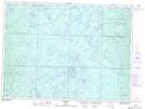
Maps showing Magog Lake, Sudbury, Ontario
Magog Lake is a Lake located in Sudbury, Ontario and has an elevation of 449 meters.
- Latitude: 47° 32' 51'' North (decimal: 47.5474999)
- Longitude: 83° 10' 45'' West (decimal: -83.1791666)
- Topography Feature Category: Lake
- Geographical Feature: Lake
- Canadian Province/Territory: Ontario
- Elevation: 449 meters
- Location: Sudbury
- Atlas of Canada Locator Map: Magog Lake
- GPS Coordinate Locator Map: Magog Lake Lat/Long