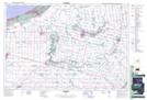
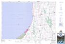
Maps showing Old Ausable Channel, Lambton, Ontario
Old Ausable Channel is a Channel located in Lambton, Ontario and has an elevation of 187 meters.
- Latitude: 43° 14' 2'' North (decimal: 43.2338888)
- Longitude: 81° 54' 17'' West (decimal: -81.9047222)
- Topography Feature Category: Channel
- Geographical Feature: Channel
- Canadian Province/Territory: Ontario
- Elevation: 187 meters
- Location: Lambton
- Atlas of Canada Locator Map: Old Ausable Channel
- GPS Coordinate Locator Map: Old Ausable Channel Lat/Long
Old Ausable Channel NTS Map Sheets