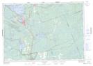
Maps showing Paul's Lake, Muskoka, Ontario
Paul's Lake is a Lake located in Muskoka, Ontario and has an elevation of 272 meters.
- Latitude: 44° 58' 16'' North (decimal: 44.9711111)
- Longitude: 79° 17' 5'' West (decimal: -79.2847222)
- Topography Feature Category: Lake
- Geographical Feature: Lake
- Canadian Province/Territory: Ontario
- Elevation: 272 meters
- Location: Muskoka
- Atlas of Canada Locator Map: Paul's Lake
- GPS Coordinate Locator Map: Paul's Lake Lat/Long
Paul's Lake NTS Map Sheets