Canada Topographic Maps

Powder Shoal Topo Maps

Topography maps and Latitude/Longitude Location

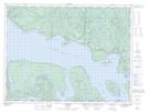
Maps showing Powder Shoal, Ontario

Powder Shoal is a Shoal located in Ontario.

  • Latitude: 48° 50' 35'' North   (decimal: 48.8430999)
  • Longitude: 87° 36' 54'' West   (decimal: -87.6149999)
  • Topography Feature Category: Shoal
  • Geographical Feature: Shoal
  • Canadian Province/Territory: Ontario
  • GPS Coordinate Locator Map: Powder Shoal Lat/Long

Powder Shoal NTS Map Sheets

042D13 Rossport Topographic Map at 1:50,000 scale

042D Schreiber Topographic Map at 1:250,000 scale

 
Buy Topographic Maps DVD
Newsletter Sign-up

Yes, I want to receive map store discounts.


Bookmark and Share