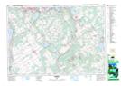
Maps showing Rumbles Mill Pond, Simcoe, Ontario
Rumbles Mill Pond is a Lake located in Simcoe, Ontario.
- Latitude: 44° 34' 57'' North (decimal: 44.5824999)
- Longitude: 79° 45' 1'' West (decimal: -79.7502777)
- Topography Feature Category: Lake
- Geographical Feature: Pond
- Canadian Province/Territory: Ontario
- Location: Simcoe
- Atlas of Canada Locator Map: Rumbles Mill Pond
- GPS Coordinate Locator Map: Rumbles Mill Pond Lat/Long
Rumbles Mill Pond NTS Map Sheets