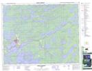
Maps showing Sioux Lookout, Kenora, Ontario
Sioux Lookout is a Unincorporated area located in Kenora, Ontario and has an elevation of 402 meters.
- Latitude: 50° 5' 25'' North (decimal: 50.0902777)
- Longitude: 91° 55' 2'' West (decimal: -91.9172222)
- Topography Feature Category: Unincorporated area
- Geographical Feature: Community
- Canadian Province/Territory: Ontario
- Elevation: 402 meters
- Location: Kenora
- Atlas of Canada Locator Map: Sioux Lookout
- GPS Coordinate Locator Map: Sioux Lookout Lat/Long
Sioux Lookout NTS Map Sheets