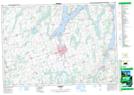
Maps showing Snug Harbour, Victoria, Ontario
Snug Harbour is a Unincorporated area located in Victoria, Ontario and has an elevation of 264 meters.
- Latitude: 44° 25' 31'' North (decimal: 44.4252777)
- Longitude: 78° 43' 24'' West (decimal: -78.7233333)
- Topography Feature Category: Unincorporated area
- Geographical Feature: Dispersed Rural Community
- Canadian Province/Territory: Ontario
- Elevation: 264 meters
- Location: Victoria
- Atlas of Canada Locator Map: Snug Harbour
- GPS Coordinate Locator Map: Snug Harbour Lat/Long
Snug Harbour NTS Map Sheets