Maps showing Stafford, Renfrew, Ontario
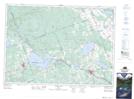
Stafford is a Geographical area located in Renfrew, Ontario.
- Latitude: 45° 42' 32'' North (decimal: 45.7088888)
- Longitude: 77° 2' 20'' West (decimal: -77.0388888)
- Topography Feature Category: Geographical area
- Geographical Feature: Geographic Township
- Canadian Province/Territory: Ontario
- Location: Renfrew
- Atlas of Canada Locator Map: Stafford
- GPS Coordinate Locator Map: Stafford Lat/Long
Stafford NTS Map Sheets