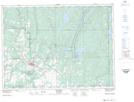
Maps showing Swift Water, Timiskaming, Ontario
Swift Water is a Channel located in Timiskaming, Ontario and has an elevation of 238 meters.
- Latitude: 47° 52' 23'' North (decimal: 47.8730555)
- Longitude: 79° 41' 11'' West (decimal: -79.6863888)
- Topography Feature Category: Channel
- Geographical Feature: Narrows
- Canadian Province/Territory: Ontario
- Elevation: 238 meters
- Location: Timiskaming
- Atlas of Canada Locator Map: Swift Water
- GPS Coordinate Locator Map: Swift Water Lat/Long
Swift Water NTS Map Sheets