Maps showing Teasdale, Algoma, Ontario
Teasdale is a Geographical area located in Algoma, Ontario.
- Latitude: 46° 34' 58'' North (decimal: 46.5827777)
- Longitude: 82° 15' 18'' West (decimal: -82.2549999)
- Topography Feature Category: Geographical area
- Geographical Feature: Geographic Township
- Canadian Province/Territory: Ontario
- Location: Algoma
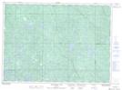
- Atlas of Canada Locator Map: Teasdale
- GPS Coordinate Locator Map: Teasdale Lat/Long
Teasdale NTS Map Sheets