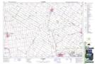
Maps showing Thames Road, Huron, Ontario
Thames Road is a Unincorporated area located in Huron, Ontario and has an elevation of 293 meters.
- Latitude: 43° 22' 13'' North (decimal: 43.3702777)
- Longitude: 81° 24' 35'' West (decimal: -81.4097222)
- Topography Feature Category: Unincorporated area
- Geographical Feature: Dispersed Rural Community
- Canadian Province/Territory: Ontario
- Elevation: 293 meters
- Location: Huron
- Atlas of Canada Locator Map: Thames Road
- GPS Coordinate Locator Map: Thames Road Lat/Long