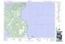
Maps showing The Forty Hills, Bruce, Ontario
The Forty Hills is a Mountain located in Bruce, Ontario and has an elevation of 214 meters.
- Latitude: 45° 2' 29'' North (decimal: 45.0413888)
- Longitude: 81° 17' 19'' West (decimal: -81.2886111)
- Topography Feature Category: Mountain
- Geographical Feature: Hills
- Canadian Province/Territory: Ontario
- Elevation: 214 meters
- Location: Bruce
- Atlas of Canada Locator Map: The Forty Hills
- GPS Coordinate Locator Map: The Forty Hills Lat/Long
The Forty Hills NTS Map Sheets