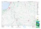
Maps showing Underwood, Bruce, Ontario
Underwood is a Unincorporated area located in Bruce, Ontario and has an elevation of 244 meters.
- Latitude: 44° 18' 25'' North (decimal: 44.3069444)
- Longitude: 81° 29' 2'' West (decimal: -81.4838888)
- Topography Feature Category: Unincorporated area
- Geographical Feature: Compact Rural Community
- Canadian Province/Territory: Ontario
- Elevation: 244 meters
- Location: Bruce
- Atlas of Canada Locator Map: Underwood
- GPS Coordinate Locator Map: Underwood Lat/Long