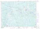
Maps showing Upper Burnt Chute, Ontario
Upper Burnt Chute is a Falls located in Ontario.
- Latitude: 45° 42' 36'' North (decimal: 45.7100000)
- Longitude: 79° 54' 58'' West (decimal: -79.9161000)
- Topography Feature Category: Falls
- Geographical Feature: Chute
- Canadian Province/Territory: Ontario
- GPS Coordinate Locator Map: Upper Burnt Chute Lat/Long
Upper Burnt Chute NTS Map Sheets