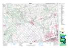
Maps showing Vellore, York, Ontario
Vellore is a Unincorporated area located in York, Ontario and has an elevation of 216 meters.
- Latitude: 43° 50' 00'' North (decimal: 43.8333333)
- Longitude: 79° 33' 27'' West (decimal: -79.5575000)
- Topography Feature Category: Unincorporated area
- Geographical Feature: Compact Rural Community
- Canadian Province/Territory: Ontario
- Elevation: 216 meters
- Location: York
- Atlas of Canada Locator Map: Vellore
- GPS Coordinate Locator Map: Vellore Lat/Long