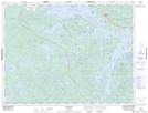
Maps showing Christie's Island, Kenora, Ontario
Christie's Island is a Island located in Kenora, Ontario and has an elevation of 372 meters.
- Latitude: 49° 43' 52'' North (decimal: 49.7311111)
- Longitude: 92° 39' 11'' West (decimal: -92.6530555)
- Topography Feature Category: Island
- Geographical Feature: Island
- Canadian Province/Territory: Ontario
- Elevation: 372 meters
- Location: Kenora
- Atlas of Canada Locator Map: Christie's Island
- GPS Coordinate Locator Map: Christie's Island Lat/Long