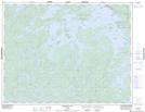
Maps showing Barber Pole, Kenora, Ontario
Barber Pole is a Shoal located in Kenora, Ontario.
- Latitude: 49° 42' 15'' North (decimal: 49.7041666)
- Longitude: 93° 10' 39'' West (decimal: -93.1774999)
- Topography Feature Category: Shoal
- Geographical Feature: Reef
- Canadian Province/Territory: Ontario
- Location: Kenora
- Atlas of Canada Locator Map: Barber Pole
- GPS Coordinate Locator Map: Barber Pole Lat/Long
Barber Pole NTS Map Sheets