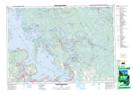
Maps showing Gibson River Provincial Nature Reserve, Muskoka, Ontario
Gibson River Provincial Nature Reserve is a Conservation area located in Muskoka, Ontario and has an elevation of 209 meters.
- Latitude: 44° 56' 24'' North (decimal: 44.94)
- Longitude: 79° 41' 59'' West (decimal: -79.6997221)
- Topography Feature Category: Conservation area
- Geographical Feature: Provincial Nature Reserve
- Canadian Province/Territory: Ontario
- Elevation: 209 meters
- Location: Muskoka
- Atlas of Canada Locator Map: Gibson River Provincial Nature Reserve
- GPS Coordinate Locator Map: Gibson River Provincial Nature Reserve Lat/Long
Gibson River Provincial Nature Reserve NTS Map Sheets