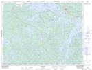
Maps showing Peg Leg Joe's Bay, Kenora, Ontario
Peg Leg Joe's Bay is a Bay located in Kenora, Ontario and has an elevation of 376 meters.
- Latitude: 49° 40' 42'' North (decimal: 49.6783333)
- Longitude: 92° 42' 1'' West (decimal: -92.7002777)
- Topography Feature Category: Bay
- Geographical Feature: Bay
- Canadian Province/Territory: Ontario
- Elevation: 376 meters
- Location: Kenora
- Atlas of Canada Locator Map: Peg Leg Joe's Bay
- GPS Coordinate Locator Map: Peg Leg Joe's Bay Lat/Long