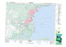
Maps showing The Nor'Westers, Thunder Bay, Ontario
The Nor'Westers is a Mountain located in Thunder Bay, Ontario and has an elevation of 245 meters.
- Latitude: 48° 17' 19'' North (decimal: 48.2886111)
- Longitude: 89° 21' 29'' West (decimal: -89.3580555)
- Topography Feature Category: Mountain
- Geographical Feature: Ridge
- Canadian Province/Territory: Ontario
- Elevation: 245 meters
- Location: Thunder Bay
- Atlas of Canada Locator Map: The Nor'Westers
- GPS Coordinate Locator Map: The Nor'Westers Lat/Long
The Nor'Westers NTS Map Sheets