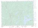
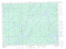
Maps showing McGill Lake, Thunder Bay, Ontario
McGill Lake is a Lake located in Thunder Bay, Ontario and has an elevation of 332 meters.
- Latitude: 48° 55' 13'' North (decimal: 48.9202777)
- Longitude: 85° 30' 11'' West (decimal: -85.5030555)
- Topography Feature Category: Lake
- Geographical Feature: Lake
- Canadian Province/Territory: Ontario
- Elevation: 332 meters
- Location: Thunder Bay
- Atlas of Canada Locator Map: McGill Lake
- GPS Coordinate Locator Map: McGill Lake Lat/Long
McGill Lake NTS Map Sheets