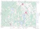
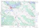
Maps showing The Burnt Lands, Carleton; Lanark, Ontario
The Burnt Lands is a Forest located in Carleton; Lanark, Ontario and has an elevation of 146 meters.
- Latitude: 45° 16' 2'' North (decimal: 45.2672222)
- Longitude: 76° 8' 10'' West (decimal: -76.1361111)
- Topography Feature Category: Forest
- Geographical Feature: Woods
- Canadian Province/Territory: Ontario
- Elevation: 146 meters
- Location: Carleton; Lanark
- Atlas of Canada Locator Map: The Burnt Lands
- GPS Coordinate Locator Map: The Burnt Lands Lat/Long
The Burnt Lands NTS Map Sheets