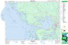
Maps showing Pina Blanco Point, Parry Sound, Ontario
Pina Blanco Point is a Cape located in Parry Sound, Ontario and has an elevation of 180 meters.
- Latitude: 45° 16' 22'' North (decimal: 45.2727777)
- Longitude: 80° 5' 15'' West (decimal: -80.0874999)
- Topography Feature Category: Cape
- Geographical Feature: Point
- Canadian Province/Territory: Ontario
- Elevation: 180 meters
- Location: Parry Sound
- Atlas of Canada Locator Map: Pina Blanco Point
- GPS Coordinate Locator Map: Pina Blanco Point Lat/Long
Pina Blanco Point NTS Map Sheets