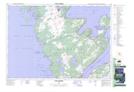
Maps showing Pine Tree Point, Bruce, Ontario
Pine Tree Point is a Cape located in Bruce, Ontario and has an elevation of 177 meters.
- Latitude: 44° 56' 42'' North (decimal: 44.9450000)
- Longitude: 81° 3' 19'' West (decimal: -81.0552777)
- Topography Feature Category: Cape
- Geographical Feature: Point
- Canadian Province/Territory: Ontario
- Elevation: 177 meters
- Location: Bruce
- Atlas of Canada Locator Map: Pine Tree Point
- GPS Coordinate Locator Map: Pine Tree Point Lat/Long
Pine Tree Point NTS Map Sheets