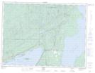
Maps showing Moonlight Beach, Thunder Bay, Ontario
Moonlight Beach is a Beach located in Thunder Bay, Ontario and has an elevation of 189 meters.
- Latitude: 48° 31' 21'' North (decimal: 48.5225000)
- Longitude: 88° 38' 51'' West (decimal: -88.6474999)
- Topography Feature Category: Beach
- Geographical Feature: Beach
- Canadian Province/Territory: Ontario
- Elevation: 189 meters
- Location: Thunder Bay
- Atlas of Canada Locator Map: Moonlight Beach
- GPS Coordinate Locator Map: Moonlight Beach Lat/Long