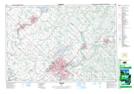
Maps showing Shand Dam, Wellington, Ontario
Shand Dam is a Hydraulic construction located in Wellington, Ontario and has an elevation of 409 meters.
- Latitude: 43° 44' North (decimal: 43.7332999)
- Longitude: 80° 20' West (decimal: -80.3333000)
- Topography Feature Category: Hydraulic construction
- Geographical Feature: Dam
- Canadian Province/Territory: Ontario
- Elevation: 409 meters
- Location: Wellington
- Atlas of Canada Locator Map: Shand Dam
- GPS Coordinate Locator Map: Shand Dam Lat/Long