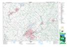
Maps showing Sayers Mills, Halton, Ontario
Sayers Mills is a Unincorporated area located in Halton, Ontario and has an elevation of 328 meters.
- Latitude: 43° 32' 44'' North (decimal: 43.5455555)
- Longitude: 80° 0' 53'' West (decimal: -80.0147222)
- Topography Feature Category: Unincorporated area
- Geographical Feature: Dispersed Rural Community
- Canadian Province/Territory: Ontario
- Elevation: 328 meters
- Location: Halton
- Atlas of Canada Locator Map: Sayers Mills
- GPS Coordinate Locator Map: Sayers Mills Lat/Long