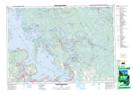
Maps showing One Tree Island, Muskoka, Ontario
One Tree Island is a Island located in Muskoka, Ontario and has an elevation of 181 meters.
- Latitude: 44° 56' 30'' North (decimal: 44.9416666)
- Longitude: 79° 53' 28'' West (decimal: -79.8911111)
- Topography Feature Category: Island
- Geographical Feature: Island
- Canadian Province/Territory: Ontario
- Elevation: 181 meters
- Location: Muskoka
- Atlas of Canada Locator Map: One Tree Island
- GPS Coordinate Locator Map: One Tree Island Lat/Long
One Tree Island NTS Map Sheets