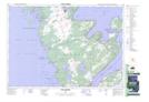
Maps showing Parker Landing, Bruce, Ontario
Parker Landing is a Unincorporated area located in Bruce, Ontario.
- Latitude: 44° 57' 36'' North (decimal: 44.9599999)
- Longitude: 81° 21' 27'' West (decimal: -81.3574999)
- Topography Feature Category: Unincorporated area
- Geographical Feature: Locality
- Canadian Province/Territory: Ontario
- Location: Bruce
- Atlas of Canada Locator Map: Parker Landing
- GPS Coordinate Locator Map: Parker Landing Lat/Long
Parker Landing NTS Map Sheets