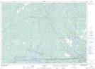
Maps showing Bill's Bay, Parry Sound, Ontario
Bill's Bay is a Bay located in Parry Sound, Ontario and has an elevation of 180 meters.
- Latitude: 46° 0' 35'' North (decimal: 46.0097222)
- Longitude: 80° 51' 44'' West (decimal: -80.8622222)
- Topography Feature Category: Bay
- Geographical Feature: Bay
- Canadian Province/Territory: Ontario
- Elevation: 180 meters
- Location: Parry Sound
- Atlas of Canada Locator Map: Bill's Bay
- GPS Coordinate Locator Map: Bill's Bay Lat/Long