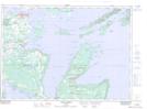
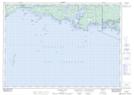
Maps showing Azov Ledges, Manitoulin, Ontario
Azov Ledges is a Shoal located in Manitoulin, Ontario.
- Latitude: 45° 48' 32'' North (decimal: 45.8088888)
- Longitude: 81° 29' 34'' West (decimal: -81.4927777)
- Topography Feature Category: Shoal
- Geographical Feature: Ledges
- Canadian Province/Territory: Ontario
- Location: Manitoulin
- Atlas of Canada Locator Map: Azov Ledges
- GPS Coordinate Locator Map: Azov Ledges Lat/Long
Azov Ledges NTS Map Sheets