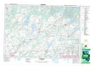
Maps showing Basswood Hill, Lennox and Addington, Ontario
Basswood Hill is a Mountain located in Lennox and Addington, Ontario and has an elevation of 182 meters.
- Latitude: 44° 25' 10'' North (decimal: 44.4194444)
- Longitude: 76° 55' 14'' West (decimal: -76.9205555)
- Topography Feature Category: Mountain
- Geographical Feature: Hill
- Canadian Province/Territory: Ontario
- Elevation: 182 meters
- Location: Lennox and Addington
- Atlas of Canada Locator Map: Basswood Hill
- GPS Coordinate Locator Map: Basswood Hill Lat/Long