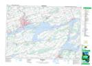
Maps showing Fish House Island, Hastings, Ontario
Fish House Island is a Island located in Hastings, Ontario.
- Latitude: 44° 6' 59'' North (decimal: 44.1163888)
- Longitude: 77° 29' 21'' West (decimal: -77.4891666)
- Topography Feature Category: Island
- Geographical Feature: Island
- Canadian Province/Territory: Ontario
- Location: Hastings
- Atlas of Canada Locator Map: Fish House Island
- GPS Coordinate Locator Map: Fish House Island Lat/Long
Fish House Island NTS Map Sheets