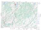
Maps showing Chisholm's Mills, Hastings, Ontario
Chisholm's Mills is a Unincorporated area located in Hastings, Ontario and has an elevation of 132 meters.
- Latitude: 44° 21' 13'' North (decimal: 44.3536111)
- Longitude: 77° 18' 35'' West (decimal: -77.3097222)
- Topography Feature Category: Unincorporated area
- Geographical Feature: Locality
- Canadian Province/Territory: Ontario
- Elevation: 132 meters
- Location: Hastings
- Atlas of Canada Locator Map: Chisholm's Mills
- GPS Coordinate Locator Map: Chisholm's Mills Lat/Long