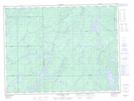
Maps showing Shabotik, Thunder Bay, Ontario
Shabotik is a Geographical area located in Thunder Bay, Ontario.
- Latitude: 48° 55' 59'' North (decimal: 48.9330555)
- Longitude: 85° 23' 40'' West (decimal: -85.3944444)
- Topography Feature Category: Geographical area
- Geographical Feature: Geographic Township
- Canadian Province/Territory: Ontario
- Location: Thunder Bay
- Atlas of Canada Locator Map: Shabotik
- GPS Coordinate Locator Map: Shabotik Lat/Long
Shabotik NTS Map Sheets