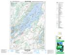
Maps showing Baby Tar Island, Leeds, Ontario
Baby Tar Island is a Island located in Leeds, Ontario.
- Latitude: 44° 23' 4'' North (decimal: 44.3844444)
- Longitude: 75° 54' 50'' West (decimal: -75.9138888)
- Topography Feature Category: Island
- Geographical Feature: Island
- Canadian Province/Territory: Ontario
- Location: Leeds
- Atlas of Canada Locator Map: Baby Tar Island
- GPS Coordinate Locator Map: Baby Tar Island Lat/Long
Baby Tar Island NTS Map Sheets