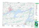
Maps showing Robinson Cove, Prince Edward, Ontario
Robinson Cove is a Bay located in Prince Edward, Ontario and has an elevation of 89 meters.
- Latitude: 44° 6' 50'' North (decimal: 44.1138888)
- Longitude: 77° 16' 51'' West (decimal: -77.2808333)
- Topography Feature Category: Bay
- Geographical Feature: Cove
- Canadian Province/Territory: Ontario
- Elevation: 89 meters
- Location: Prince Edward
- Atlas of Canada Locator Map: Robinson Cove
- GPS Coordinate Locator Map: Robinson Cove Lat/Long
Robinson Cove NTS Map Sheets