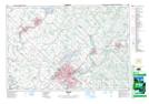
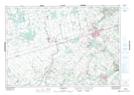
Maps showing Belwood Lake Conservation Area, Ontario
Belwood Lake Conservation Area is a Conservation area located in Ontario and has an elevation of 434 meters.
- Latitude: 43° 46' North (decimal: 43.7666999)
- Longitude: 80° 20' West (decimal: -80.3333000)
- Topography Feature Category: Conservation area
- Geographical Feature: Conservation Area
- Canadian Province/Territory: Ontario
- Elevation: 434 meters
- Atlas of Canada Locator Map: Belwood Lake Conservation Area
- GPS Coordinate Locator Map: Belwood Lake Conservation Area Lat/Long
Belwood Lake Conservation Area NTS Map Sheets