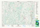
Maps showing Flesherton Community Pond, Grey, Ontario
Flesherton Community Pond is a Lake located in Grey, Ontario.
- Latitude: 44° 15' 33'' North (decimal: 44.2591666)
- Longitude: 80° 33' 20'' West (decimal: -80.5555555)
- Topography Feature Category: Lake
- Geographical Feature: Pond
- Canadian Province/Territory: Ontario
- Location: Grey
- Atlas of Canada Locator Map: Flesherton Community Pond
- GPS Coordinate Locator Map: Flesherton Community Pond Lat/Long
Flesherton Community Pond NTS Map Sheets