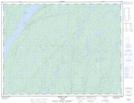
Maps showing Stewart Lake, Thunder Bay, Ontario
Stewart Lake is a Lake located in Thunder Bay, Ontario.
- Latitude: 49° 17' 33'' North (decimal: 49.2925000)
- Longitude: 86° 43' 5'' West (decimal: -86.7180555)
- Topography Feature Category: Lake
- Geographical Feature: Lake
- Canadian Province/Territory: Ontario
- Location: Thunder Bay
- Atlas of Canada Locator Map: Stewart Lake
- GPS Coordinate Locator Map: Stewart Lake Lat/Long
Stewart Lake NTS Map Sheets