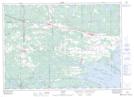
Maps showing Île à Chaput, Nipissing, Ontario
Île à Chaput is a Island located in Nipissing, Ontario.
- Latitude: 46° 19' 5'' North (decimal: 46.3180999)
- Longitude: 80° 3' 52'' West (decimal: -80.0644000)
- Topography Feature Category: Island
- Geographical Feature: Île / Ile
- Canadian Province/Territory: Ontario
- Location: Nipissing
- Atlas of Canada Locator Map: Île à Chaput
- GPS Coordinate Locator Map: Île à Chaput Lat/Long