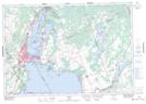
Maps showing Île Beausoleil, Muskoka, Ontario
Île Beausoleil is a Island located in Muskoka, Ontario.
- Latitude: 44° 53' North (decimal: 44.8833000)
- Longitude: 79° 52' West (decimal: -79.8667000)
- Topography Feature Category: Island
- Geographical Feature: Île / Ile
- Canadian Province/Territory: Ontario
- Location: Muskoka
- Atlas of Canada Locator Map: Île Beausoleil
- GPS Coordinate Locator Map: Île Beausoleil Lat/Long
Île Beausoleil NTS Map Sheets