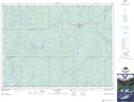
Maps showing Lac St-Paul, Timiskaming, Ontario
Lac St-Paul is a Lake located in Timiskaming, Ontario.
- Latitude: 47° 58' North (decimal: 47.9666999)
- Longitude: 80° 34' West (decimal: -80.5666999)
- Topography Feature Category: Lake
- Geographical Feature: Lac
- Canadian Province/Territory: Ontario
- Location: Timiskaming
- Atlas of Canada Locator Map: Lac St-Paul
- GPS Coordinate Locator Map: Lac St-Paul Lat/Long