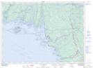
Maps showing Windreach Island, Parry Sound, Ontario
Windreach Island is a Island located in Parry Sound, Ontario.
- Latitude: 45° 55' 00'' North (decimal: 45.9166666)
- Longitude: 80° 48' 46'' West (decimal: -80.8127777)
- Topography Feature Category: Island
- Geographical Feature: Island
- Canadian Province/Territory: Ontario
- Location: Parry Sound
- Atlas of Canada Locator Map: Windreach Island
- GPS Coordinate Locator Map: Windreach Island Lat/Long
Windreach Island NTS Map Sheets