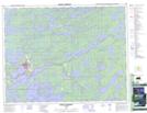
Maps showing Starratt Islands, Kenora, Ontario
Starratt Islands is a Island located in Kenora, Ontario.
- Latitude: 50° 11' 41'' North (decimal: 50.1947222)
- Longitude: 91° 57' 59'' West (decimal: -91.9663888)
- Topography Feature Category: Island
- Geographical Feature: Islands
- Canadian Province/Territory: Ontario
- Location: Kenora
- Atlas of Canada Locator Map: Starratt Islands
- GPS Coordinate Locator Map: Starratt Islands Lat/Long
Starratt Islands NTS Map Sheets